$40.57
Add to Cart
HD VUS010R BlueChart G2 Vision MARINE GPS MAP FOR GARMIN GPS/SOUNDER on micro SD
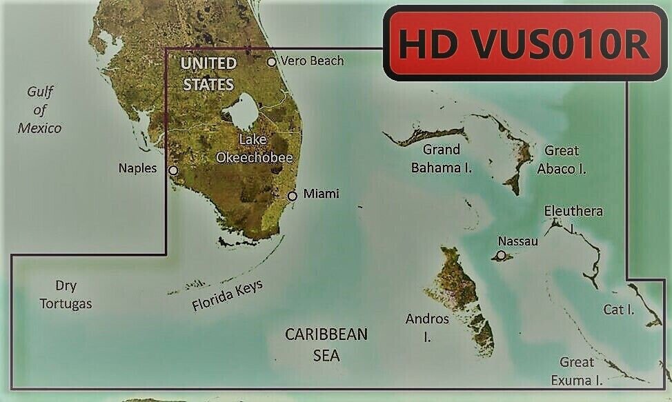


Bluechart G2 Vision HD Southeast Florida Chart on microSD/SD - VUS010R Package includes: pre-loaded MicroSD map card, and an optional full size SD adapter is available upon request. Works in GPS models listed in the compatible device list. You may use HomePort on your computer with this digital map to plan your routes/trips. At checkout, leave us a message/note indicating your GPS model. Domestic shipping is via USPS first class with tracking, expedited shipping is available. Bluechart G2 Vision HD cards enhance a compatible Garmin Chartplotter with the following detail: Up to 1-foot HD contours provide a more accurate depiction of bottom structure for improved fishing charts and navigation in swamps, canals, marinas and port plansHigh-resolution satellite imagery when overlaid on the chart, will provide the mariner with unparalleled situational awarenessAerial reference photography provides “real world” photos of ports, harbors, marinas, waterways, navigation landmarks and other points of interest, offering the mariner another powerful tool for navigating unfamiliar watersMariners Eye view – Provides the mariner with a 3-D perspective of chart information for a quick, reliable and easy position fixFish Eye view – 3D perspective below the water line for displaying bottom contours based on bathymetric charting dataAuto guidance technology will search the attributes of all relevant charts to suggest the best course for navigationFishing charts, tides, currents, marine services, coastal roads and points of interest detailPatented Garmin Auto Guidance technology is now capable of providing routing guidance¹ to virtually any accessible destination on the water. Coverage: Featuring data from Explorer Charts for the Bahamas. Vero Beach south to include Lake Okeechobee, Florida Keys, Dry Tortugas, and covering the west coast of Florida north to Naples. Also covered all the Bahamas, Andros Island, Eleuthera Island, Cat Island, Great Exuma Island, Little Exuma Island, and Hog Cay.Compatible Devices: echoMAP™ 43dv / 44dv / 50dv / 50s / 53dv / 54dv / 70dv / 70s / 73dv / 73sv / 74dv / 74sv / 93sv / 94sv echoMAP™ CHIRP 42cv / 42dv / 43cv / 43dv / 44cv / 44dv / 45cv / 45dv / 52cv / 52dv / 53cv / 53dv / 54cv / 54dv / 55cv / 55dv / 72cv / 72dv / 72sv / 73cv / 73dv / 73sv / 74cv / 74dv / 74sv / 75cv / 75dv / 75sv / 92sv / 93sv / 94sv / 95sv Not compatible in echoMAP Plus and echomap UHD models GPSMAP / 276 Cx / 4008 / 4010 / 4012 / 420/420s / 4208 / 421 / 4210 / 4212 / 421s / 430/430s / 431 / 431s / 440/440s / 441 / 441s / 5008 / 5012 / 5015 / 520/520s / 5208 / 521 / 521s / 5212 / 5215 / 525/525s / 526/526s / 1020xs / 1040xs GPSMAP 527xs / 530/530s / 531 / 531s / 535/535s / 536 / 536s / 540/540s / 541 / 541s / 545/545s / 546 / 546s / 547 / 547xs / 6208 / 6212 / 62s / 62st / 640 / 64 / 64csx / 64s / 64sc / 64st / 64sx / 64x / 65 / 65s / 720 / 720s / 722 / 722xs / 7212 / 7215 / 722 / 740 / 740s / 7407 / 7407xsv / 740s / 7408 / 741 / 741xs / 7410 / 7410xsv / 7412 / 7412xsv / 7416 / 7416xsv / 741xs / 7607 / 7608 / 7610 / 7612 / 7616 / 78 / 78s / 78sc / 840xs / 86i / 86s / 86sc Monterra®Oregon® 700 / 750 / 750t Rino® 750 / 755tVolvo Penta Glass Cockpit System (GPSMAP 8000V) If you have questions, please let us know. OpenStreetMap® is open data, licensed under the Open Data Commons Open Database License (ODbL) by the OpenStreetMap Foundation (OSMF) "Garmin" is a registered trademark Garmin Ltd Photos are for reference only

