
$109.47
Add to Cart
VAW450S BlueChart G2 MARINE GPS MAP micro SD/SD FOR GARMIN GPS
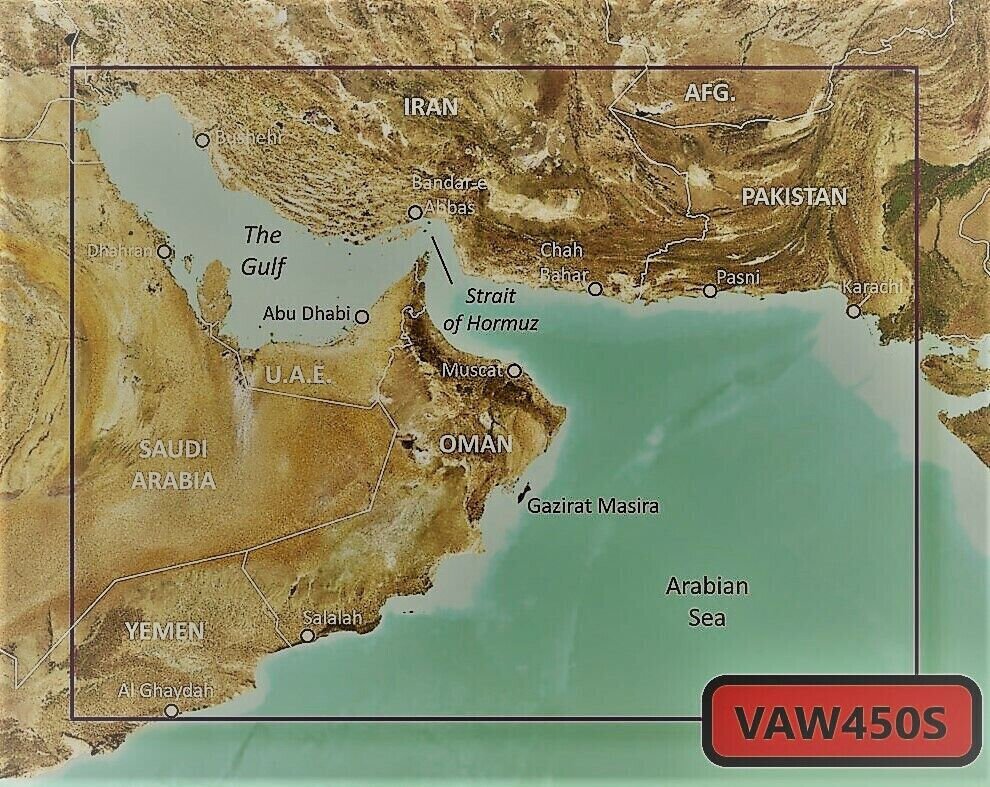


VAW450S BlueChart G2 Vision MARINE GPS MAP micro SD/SD FOR GARMIN GPS/SOUNDER Please make sure your device has a card slot that accepts either SD or micro SD format before purchasing. Package includes: Micro SD card (opionl withFull size SD adapter). Works in Garmin handheld GPS units or chartplotters that accept a micro SD card or full size SD card. You may use HomePort on your computer with this digital map to plan your routes/trips. At checkout, leave us a message indicating your GPS model. This version is not locked so it can be used in mulitple units that are compatible, it only works in a compatible gps. Features Includes realistic navigation features showing everything from shaded depth contours and coastlines to spot soundings, navaids, port plans, wrecks, obstructions, intertidal zones, restricted areas, IALA symbols and more.Features smooth displays, including seamless transitions between zoom levels and more continuity across chart boundaries.Allows users to choose between standard 2-D direct overhead or 3-D ""over the bow"" map perspective to make chart reading and orientation easier.Provides Safety Shading (in compatible units), allowing mariners to enable contour shading for all depth contours shallower than user-defined safe depths.Provides Fishing Charts (in compatible units), allowing mariners to scope out bottom contours and depth soundings with less visual clutter on the display. Coverage: Detailed coverage of Kuwait, Saudi Arabia, Qatar, United Arab Emirates, along the southern coast of the Gulf, including Al-Fuhaihil, Ad-Dammam, Bahrain, Ad-Dauha, and Abu Dhabi. Coverage of Iran along the northern coast of the Gulf including Bushehr and Bandar-e Abbas. Coverage of the Strait of Hormuz and the Gulf of Oman. General coverage of the Arabian Sea from Qamar Bay to the Delta of the Indus River.Compatible Devices: echoMAP™ 43dv / 44dv / 50dv / 50s / 53dv / 54dv / 70dv / 70s / 73dv / 73sv / 74dv / 74sv / 93sv / 94sv echoMAP™ CHIRP 42cv / 42dv / 43cv / 43dv / 44cv / 44dv / 45cv / 45dv / 52cv / 52dv / 53cv / 53dv / 54cv / 54dv / 55cv / 55dv / 72cv / 72dv / 72sv / 73cv / 73dv / 73sv / 74cv / 74dv / 74sv / 75cv / 75dv / 75sv / 92sv / 93sv / 94sv / 95sv Not compatible in echoMAP Plus and UHD models GPSMAP / 276 Cx / 4008 / 4010 / 4012 / 420/420s / 4208 / 421 / 4210 / 4212 / 421s / 430/430s / 431 / 431s / 440/440s / 441 / 441s / 5008 / 5012 / 5015 / 520/520s / 5208 / 521 / 521s / 5212 / 5215 / 525/525s / 526/526s / 1020xs / 1040xs GPSMAP 527xs / 530/530s / 531 / 531s / 535/535s / 536 / 536s / 540/540s / 541 / 541s / 545/545s / 546 / 546s / 547 / 547xs / 6208 / 6212 / 62s / 62st / 640 / 64 / 64csx / 64s / 64sc / 64st / 64sx / 64x / 65 / 65s / 720 / 720s / 722 / 722xs / 7212 / 7215 / 722 / 740 / 740s / 7407 / 7407xsv / 740s / 7408 / 741 / 741xs / 7410 / 7410xsv / 7412 / 7416 / 741xs / 7607 / 7608 / 7610 / 7612 / 7616 / 78 / 78s / 78sc / 840xs / 86i / 86s / 86sc Monterra®Oregon® 700 / 750 / 750t Rino® 750 / 755t Volvo Penta Glass Cockpit System (GPSMAP 8000V) If you have questions, please let us know by email message on eCRATER. Buy with confidence from an eCRATER verified seller - you are protected!SATISFACTION GUARANTEED OR YOUR MONEY BACK!If you are not satisfied with your purchase for any reason you may return it to us within 30 days for full refund. SHIPPING: The sale includes a pre-loaded microSD card. If you need an SD adapter, please notify us to include one by the “Message to seller” button at the check-out screen. We ship out in the next business day after receive payment.The default shipping option is a 4-day standard shipping to any US territories. We will promptly answer any questions you might have. Tracked delivery OpenStreetMap® is open data, licensed under the Open Data Commons Open Database License (ODbL) by the OpenStreetMap Foundation (OSMF) ""Garmin"" is a registered trademark Garmin Ltd This product is not affiliated with Garmin. Photos are for reference only


