$54.56
Add to Cart
Canada LakeVu HD Charts (LCA100F) GPS Lakes Map Card for Compatible GPS
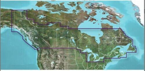


Canada LakeVu HD Charts (LCA100F) GPS Lakes Map Card for Compatible GPS Please make sure your device has a card slot that accepts either SD or micro SD format before purchasing. This version is not locked so it can be used in mulitple units that are compatible, it only works in a compatible gps.Canada LakeVu HD Charts (LCA100F) GPS Lakes Map Card for Compatible GPS Works in GPS models listed in the compatible device list. You may use HomePort on your computer with this digital map to plan your routes/trips. At checkout, leave us a message/note indicating your GPS model. Domestic shipping is via USPS first class with tracking, expedited shipping is available. COVERAGE: With maps of more than 13,500 Canadian lakes – many with up to 1-foot contours throughout – this high definition-mapping product brings new levels of detail to your chartplotter. * Contains 4,800 HD lakes with up to 1-foot contours shore-to-shore in Alberta, British Columbia, Nova Scotia, Ontario, Quebec, Saskatchewan and Yukon provinces; includes coverage for the Great Lakes and Trent Severn Waterway * Displays detailed shorelines, coastlines, streams, channels and fishing locations * Includes underwater features, such as river beds and fish attractors * Depth Range Shading for up to 10 ranges enables you to view your target depth at a glance * Offers Safety Shading — you input and shade your minimum depth to help you avoid running aground Coverage Coverage of 13,500 Canadian lakes and reservoirs covering Alberta, British Columbia, Ontario, Saskatchewan, Quebec and the Yukon Territory. Includes the Great Lakes, the St. Lawrence Seaway and the Lake of the Woods. Hudson Bay is not included. Compatible Devices: Alpha® 100Astro® 320 / 430Dakota® 20eTrex® 20 / 30 / Touch 25 / Touch 35 / Touch 35t echoMAP™ 43dv / 44dv / 50dv / 50s / 53cv / 53dv / 54dv / 70dv / 70s / 73dv / 73sv / 74sv / 93sv / 94sv echoMAP™ CHIRP 42cv / 42dv / 43cv / 43dv / 44cv / 44dv / 45cv / 45dv / 52cv / 52dv / 53cv / 53dv / 54cv / 54dv / 55cv / 55dv / 72cv / 72dv / 72sv / 73cv / 73dv / 73sv / 74cv / 74dv / 74sv / 75cv / 75dv / 75sv / 92sv / 93sv / 94sv / 95svNOT for the echoMAP Plus and echomap UHD series! GPSMAP 276Cx / 4008 / 4010 / 4012 / 4208 / 420/420s / 421 / 4210 / 4212 / 431 / 431s / 441 / 441s / 5008 / 5012 / 5015 / 5208 / 521 / 5212 / 5215 / 520/520s / 521s / 526 / 526s / 531 / 531s / 536 / 536s / 541 / 541s / 545/545s / 546 / 546s / 62 / 6208 / 6212 / 62s / 62sc / 62st / 62stc / 64s / 64st / 640 / 66s / 720 / 720s / 721xs / 7212 / 7215 / 740 / 7407 / 7407xsv / 7408 / 7408xsv / 740s / 741 / 741xs / 7410 / 7412 / 7416 / 7607 / 7607xsv / 7608 / 7610 / 7612 / 7616 / 78 / 78s / 78sc / 840xs / 86i / 86s / 86sc / 1020xs / 1040xs Colorado® 300 / 400c / 400i / 400t Montana® 600 / 600t / 610 / 610t / 650 / 650t / 680 / 680tMonterra Oregon® 450 / 450t / 550 / 550t / 600 / 600t / 650 / 650t/750/750t Rino® 750 / 755t If you have questions, please let us know. Buy with confidence from an eCRATER verified seller - you are protected!SATISFACTION GUARANTEED OR YOUR MONEY BACK!If you are not satisfied with your purchase for any reason you may return it to us within 30 days for full refund. SHIPPING: The sale includes a pre-loaded microSD card. If you need an SD adapter, please notify us to include one by the “Message to seller” button at the check-out screen. We ship out in the next business day after receive payment.Tracked delivery by USPS First Class OpenStreetMap® is open data, licensed under the Open Data Commons Open Database License (ODbL) by the OpenStreetMap Foundation (OSMF) ""Garmin"" is a registered trademark Garmin Ltd This product is not affiliated with Garmin. Photos are for reference only

